Best USA Map PowerPoint And Google Slides Template


Customizable USA PowerPoint Template
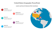
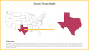
Embark on a journey across the United States with our USA Map PowerPoint template. This template not only showcases the geographical layout of the USA but also highlights specific routes, from California to Colorado, Colorado to New York, New York to Florida, and Florida to Colorado. The concept revolves around exploring these travel routes, understanding the distances, and visualizing the vast expanse of the country. It's a captivating way to engage your audience and convey information about these exciting travel connections. Ideal for travel enthusiasts, educators, and business professionals, this USA Map PowerPoint template offers a unique way to present travel routes and distances. The fully editable slides allow users to customize the map, add travel details, and enhance the visual appeal. Whether you're planning a flight trip, creating travel itineraries, or showcasing business connections across states, this template is your go-to resource. This editable template features a map of the United States with flight times between four major cities. It allows users to easily visualize travel times across the country.. Download this template now to guide your audience through exciting travel routes and inspire them to explore the diverse landscapes of the United States.
Features of this template
- 100% customizable slides and easy to download.
- Template has available in different nodes & colors.
- The slide contained 16:9 and 4:3 formats.
- Easy to change the slide colors quickly.
- It is a well-crafted template with an instant download facility.


You May Also Like These PowerPoint Templates
Add to Wishlist
Download
AI Customize

Add to Wishlist
Download
AI Customize

Add to Wishlist
Download
AI Customize

Add to Wishlist
Download
AI Customize

Add to Wishlist
Download
AI Customize

Add to Wishlist
Download
AI Customize

Add to Wishlist
Download
AI Customize

Add to Wishlist
Download
AI Customize

Add to Wishlist
Download
AI Customize

Add to Wishlist
Download
AI Customize

Add to Wishlist
Download
AI Customize

Add to Wishlist
Download
AI Customize

Add to Wishlist
Download
AI Customize

Add to Wishlist
Download
AI Customize

Add to Wishlist
Download
AI Customize

Add to Wishlist
Download
AI Customize

Add to Wishlist
Download
AI Customize

Add to Wishlist
Download
AI Customize


Add to Wishlist
Download
AI Customize
