Editable Jharkhand Map PowerPoint And Google Slides

 Canva
Canva

Jharkhand Map PPT, Google Slides, and Canva Template
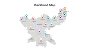
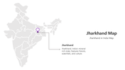
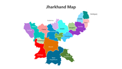
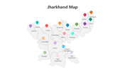
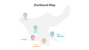
The Jharkhand Map represents the geographical and political boundaries of the Indian state of Jharkhand. Known for its rich natural resources, diverse culture, and lush landscapes, the state plays a significant role in India’s economy and heritage. The map includes details such as districts, cities, rivers, and other landmarks, making it an essential tool for understanding Jharkhand’s layout and demographics.
Purpose Of The Slides
This Jharkhand Map PowerPoint template is a comprehensive and customizable resource designed for professionals and students to present geographical, economic, or cultural insights. The 11-slide deck features a vibrant multicolor theme, providing visually engaging layouts for topics like district-wise data, development projects, or travel plans. Its user-friendly design makes it ideal for educational, corporate, and governmental presentations.
Who Can Use It?
This template is perfect for educators, researchers, government officials, and professionals working on projects related to Jharkhand. Students can also use it for academic presentations on geography, demographics, or regional development. Whether you’re highlighting tourism opportunities, development strategies, or socio-economic data, this template simplifies the process while maintaining professionalism.
Special Key Features
Download this Jharkhand Map PPT template today to create impactful and professional presentations. Simplify your geographical and data visualization needs with this versatile and easy-to-use design!
Features of this template
- 100% customizable slides and easy to download.
- The slides contain 16:9 and 4:3 formats.
- Easy to change the colors quickly.
- Highly compatible with PowerPoint, Google Slides, and Canva Presentation.


You May Also Like These PowerPoint Templates
Add to Wishlist
Download
AI Customize


Add to Wishlist
Download
AI Customize

Add to Wishlist
Download
AI Customize

Add to Wishlist
Download
AI Customize


Add to Wishlist
Download
AI Customize

Add to Wishlist
Download
AI Customize


Add to Wishlist
Download
AI Customize

Add to Wishlist
Download
AI Customize

Add to Wishlist
Download
AI Customize

Add to Wishlist
Download
AI Customize

Add to Wishlist
Download
AI Customize

Add to Wishlist
Download
AI Customize

Add to Wishlist
Download
AI Customize

Free
Add to Wishlist
Download
AI Customize

Add to Wishlist
Download
AI Customize


Add to Wishlist
Download
AI Customize
